Analysis Summary and Results
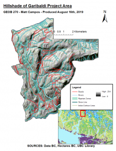
From my GIS analysis, it is apparent that the Garibaldi Resort project area overlaps with riparian zones which may feature ecologically-vulnerable aquatic populations. Moreover, As indicated by the hillshade model, these rivers extend beyond the snow line and into higher altitudes. This indicates that tourism along upper ski slopes may pose a risk to aquatic populations and thus development should consider these zones in conjunction with other protected areas (e.g. old growth management areas).
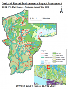
In order to produce these maps, I downloaded Old Growth Management Area (OGMA) and Ungulate Winter Range (UWR) shapefiles from Data BC. However, a source of error in this GIS analysis came up in this step. While the data warehouse’s Google Earth preview of these shapefiles indicated the full extent of the data, the actual shapefiles available from the site are only a portion of the data which should be available. Due to this, the OGMA and UWR shapefiles in this study are not completely accurate to the real UWR and OGMA areas. Working with this limitation, I continued to conduct the rest of my analysis accordingly. I also imported data of the proposed project boundary, land use data from HectaresBC, and TRIM data of elevation contours, roads, and rivers into my geodatabase. I subsequently projected layers in BC Albers to NAD 1983 UTM Zone 10N.
In order to calculate the percentage of the project area below 600m in elevation, I reclassified the DEM, converted the reclassification into a polygon, then clipped that polygon to the project boundary. With this, I was able to divide the sub-600m elevation by the total project area which equals approximately 46.6% of the total area. However, with respect to overlap between certain species ranges plus winter ranges and the project boundary, this study found no overlap from clipping the files together. As previously discussed, this is due to the missing data files from Data BC’s website and thus is an indication of error which should be considered.
The next important figure to calculate was the percentage of riparian zones which fell within the project boundary. This was done by conducting a spatial join between the TRIM rivers file and running queries in order to generate a variable width buffer of 50m (higher elevation) or 100m (lower elevation). A buffer was generated then dissolved and clipped to the project area. The percentage calculated by this process equals about 28.70% of the total project area.
Recommendations and Sources of Error
These results indicate that much of the project area may not be suitable to ski slope development (almost 50% is low elevation as previously discussed). This may put more pressure on ski slopes to be developed in areas which, according to the landuse data layer, overlap with old forests. This places those areas at risk of deforestation and while OGMA species data is not available, it can be inferred that biodiversity may be be decreased through ecosystem fragmentation. Thus, project developers should make the best use of high-elevation areas which have already been logged or do not feature habitat of vulnerable or endemic species. Moreover, special care with respect to soil and water pollution should be taken in designing buildings and waste management systems for the resort. It may be catastrophic to downstream ecosystems for pollution to affect high-elevation riparian zones (even if they are smaller than the ones below 600 meters).
Beyond the absence of OGMA and UWR data, one other source of error in this analysis is that a variable riparian zone buffer may overgeneralize actual aquatic ecosystem ranges. The 600m cutoff for high/low elevation is useful for creating a readable model for this analysis, but its arbitrary form may not reflect actual stream morphology along slopes within the project boundary. Nonetheless, the model I have constructed is effective at indicating which areas are most suitable for development: high-elevation areas outside of old forests which are sufficiently far from riparian zones and sufficiently close to roads to minimize the cost of paving new infrastructure. While some compromises may have to be made in the planning process, the biodiversity of terrestrial and river ecosystems within the project boundary should be a critical consideration.
Here are the maps I produced:
(Click to enlarge)
By conducting buffer, multivariable query, proximity, clipping, and reclassification analyses, I further developed my applied understanding of GIS analysis functions and environmental impact assessment principles. I also produced a detailed and brief report about my maps which identified high elevation areas more suitable for development, enhancing planning knowledge about the region in question in order to protect local biodiversity.