Advanced GIS: Alberta Wildlife Crossings
Final project for GEOB 370: Advanced GIS. I produced maps and models which suggested new wildlife crossing locations along the Crowsnest Highway in Alberta, Canada.
Geography Undergraduate
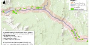
Final project for GEOB 370: Advanced GIS. I produced maps and models which suggested new wildlife crossing locations along the Crowsnest Highway in Alberta, Canada.
For this assignment, I had to produce 2 maps of the Garibaldi Resort project area near Squamish, BC to conduct an environmental impact assessment. I applied GIS analysis skills such as proximity analysis, clipping, unions, reclassifcation, area calculation, hillshade production, and multi-field queries to develop my personal skill set and identify areas of ecological concern to the project's developers.

In this activity, I was tasked with reviewing all of my accomplish statements and portfolio posts. I had to write a personal statement which describes my experience in Geography 270 and summarizes my academic findings and personal development outcomes.
In this project, I applied the lessons I learned throughout GEOB 270 to develop 3 maps of public transit use by census tract for Metro Vancouver, Montreal, and Calgary. I executed GIS analytical functions such as joins, reclassification, and field calculation in order to visualize census data. I discussed the results of my visualization in reference to literature on urban fabrics, transit-oriented development, and factors which affect public transit ridership.
In this activity, I worked with spatial and tabular datasets to highlight areas of Metro Vancouver that at risk of flooding during a storm surge. I executed geographic analysis functions such as buffers and overlays, evaluating the data integrity of my maps along the way.
For this course with Dr. Hermansen, I was tasked with classifying housing costs in Metro Vancouver with 4 different methods. In this post, I will discuss how these methods influence map interpretation and how data uncertainty and suppression create "no data" census areas on my maps.
For this course with Dr. Hermansen, I had to develop maps comparing shelter costs and housing affordability between Metro Vancouver and Montreal.